Location sharing is less accurate indoors because GPS needs a clear view of the sky, and roofs, walls and concrete block most of the satellite signal. Once a phone loses GPS it falls back on nearby Wi-Fi networks and mobile masts, which typically place you within tens of metres in a town and hundreds of metres or more in the countryside. That is why a dot lands in the house next door, drifts while someone sits still, or sits inside a large shaded circle.
Usually nothing is broken. Keeping Wi-Fi scanning on, allowing precise location and turning on Google’s Location Accuracy on Android all tighten the result, but no setting lets a phone see satellites through a roof. The most useful habit is reading the accuracy circle and the time stamp, not the pin.
What your phone is really doing indoors
A phone blends several location sources and reports its best guess, along with how confident it is. Indoors the blend changes, and so does the quality of the answer.
GPS and other satellite systems
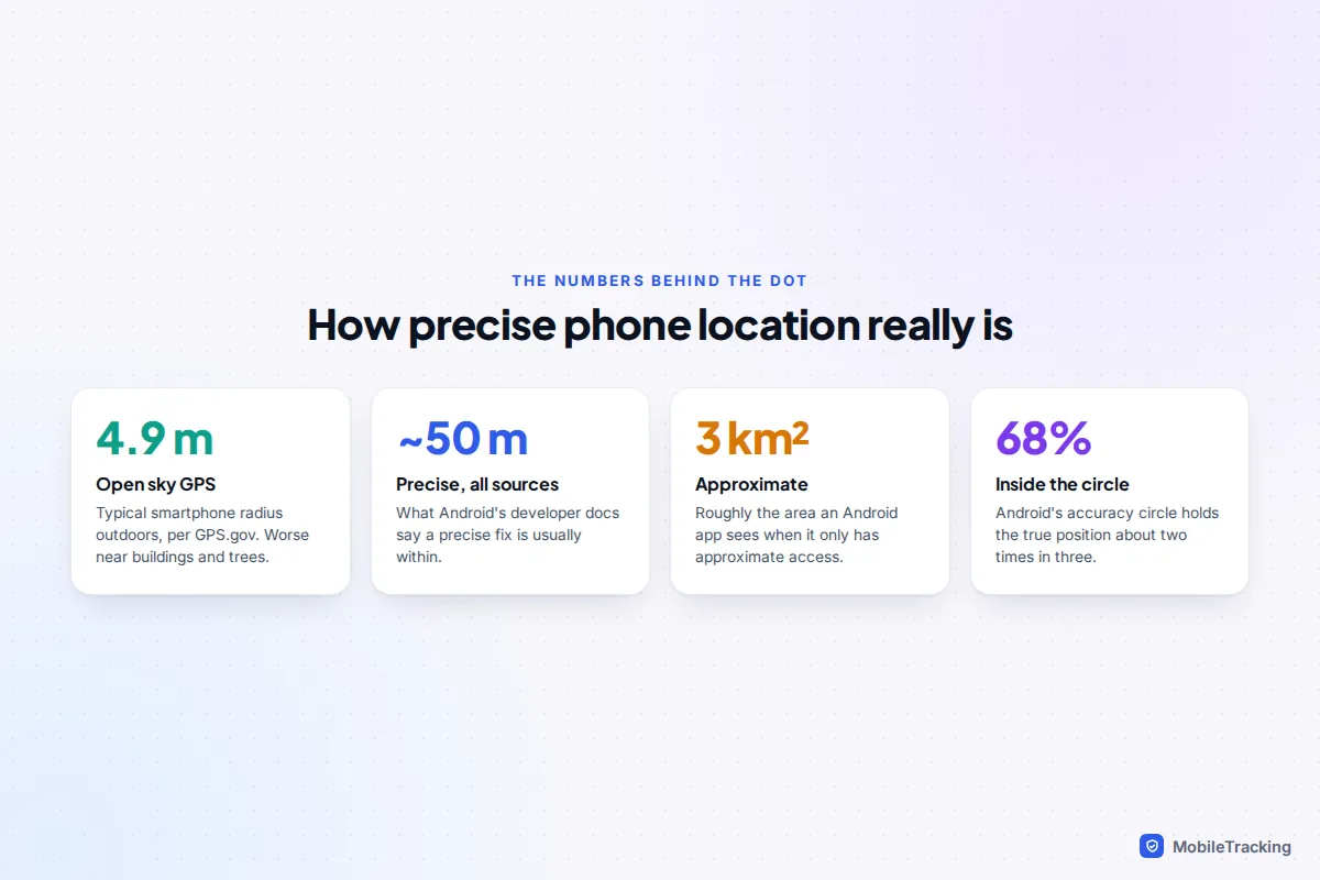
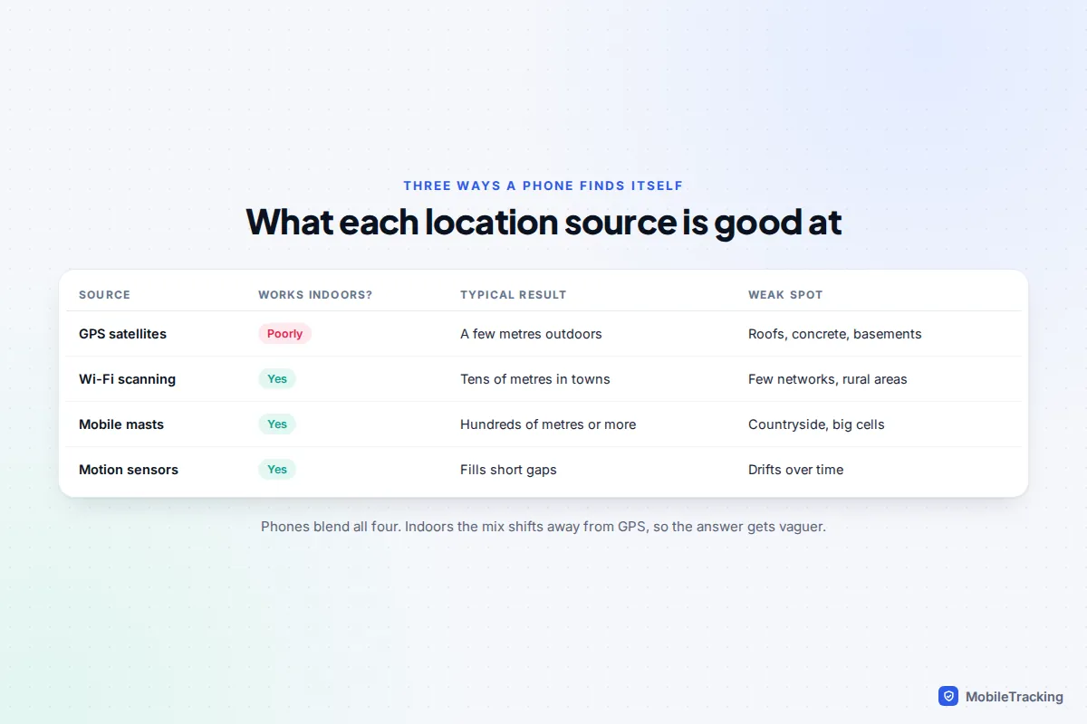
Satellite signals are extremely weak by the time they reach the ground. According to GPS.gov, the US government’s official GPS site, GPS-enabled smartphones are typically accurate to within a 4.9 m (16 ft) radius under open sky, but accuracy worsens near buildings, bridges and trees. The same page lists indoor or underground use and signals reflected off buildings as common causes of poor readings. A phone by a window may still get a usable fix; one in a basement, a lift or the middle of a large shop usually won’t.
Wi-Fi positioning
Your phone can see the Wi-Fi networks around it even if it isn’t connected to any of them. Apple and Google keep databases of where networks have been seen, so a list of nearby network names and signal strengths can be turned into a position. In a busy street full of routers this can be good to within a few tens of metres; in a village with three routers it is much rougher.
Mobile masts and sensors
When there is no GPS and little Wi-Fi, the phone can estimate its position from the mobile masts it can hear. In a city that might be a few hundred metres; in the countryside, where one mast covers a wide area, it can be out by a kilometre or more. Motion sensors, the compass and the barometer help smooth the gaps between fixes, but they drift if they have to work alone for long.
For scale, a widely cited 2009 academic study of iPhone locations found median errors of about 8 m for assisted GPS, 74 m for Wi-Fi and 600 m for mobile masts. Wi-Fi databases are far denser today, but the order still holds.
How to read the accuracy circle
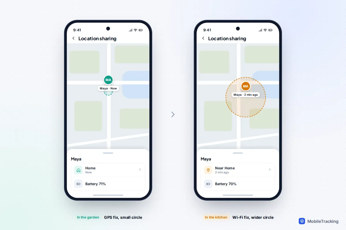
The shaded circle around a location dot is the phone admitting it isn’t sure. Google’s help page for Maps describes it plainly: when Maps can’t pinpoint where you are, a light blue circle around the blue dot shows the range of possible locations, and the smaller the circle, the more precise the fix.
Android’s developer documentation defines the radius as 68% confidence: roughly a two-in-three chance the true position is inside the circle, so about one time in three the person is outside it. Apple calls its figure a radius of uncertainty without naming a percentage. Either way, the centre of the circle is just the middle of the phone’s guess.
Three quick rules help:
- Small circle, a few metres across: almost certainly a GPS fix, usually outdoors or by a window.
- Circle the size of a block or two: Wi-Fi positioning. The person is very likely in the area but may not be in the building under the pin.
- Circle covering a neighbourhood or more: mast-only positioning, or the app has only approximate permission.
Not every app draws a circle. Many family and messaging apps show only a pin or profile photo, which looks confident even when the fix is vague. Then the time stamp and a little context are your only clues.
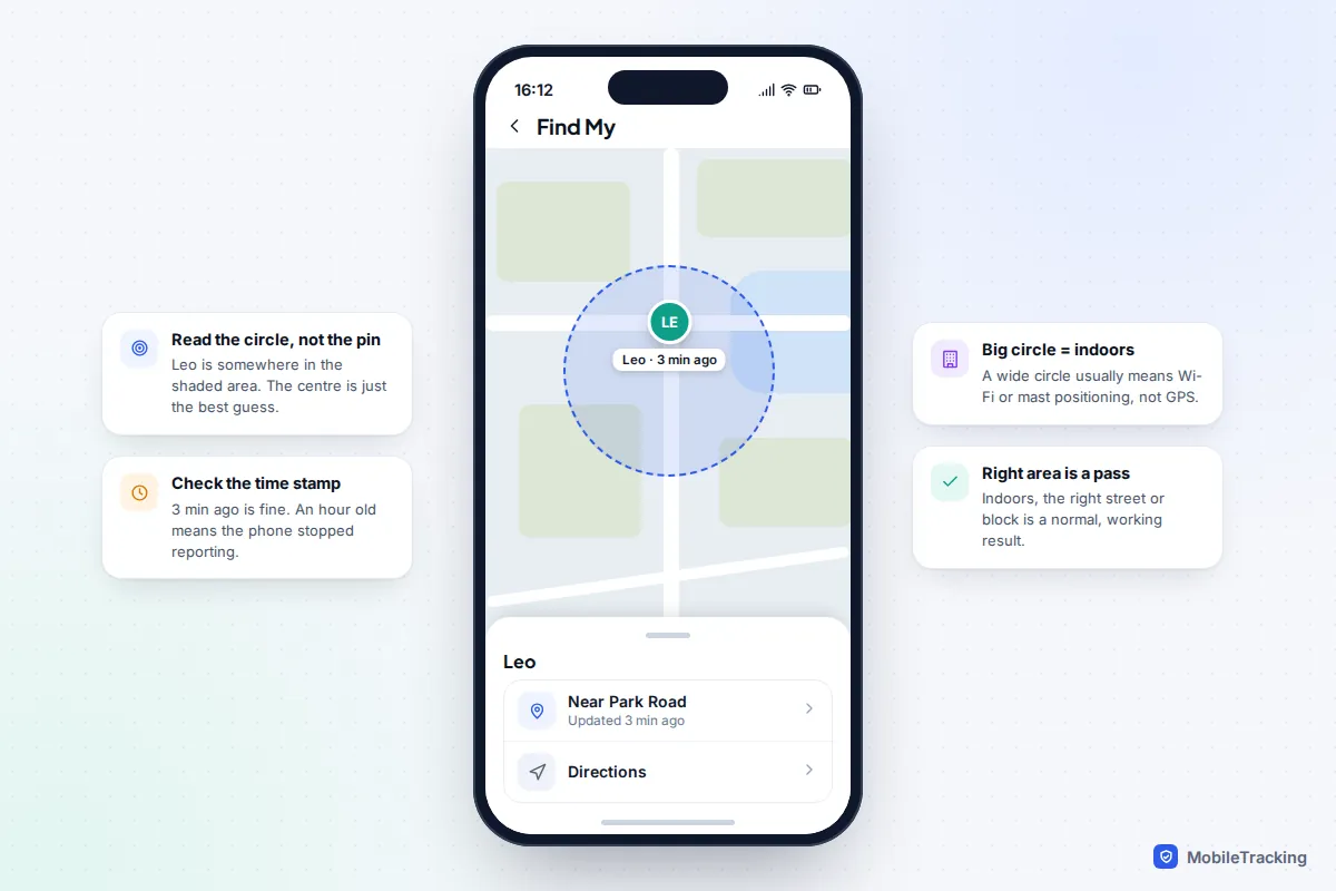
The same person can produce very different circles minutes apart: step outside and GPS takes over; walk back into the kitchen and the circle widens again.
Why cities and tall buildings make it worse
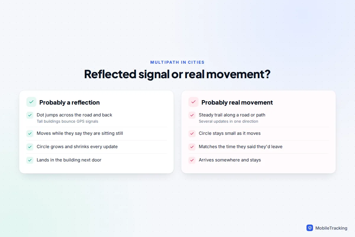
In a city centre the problem isn’t only blocked signals. Satellite signals bounce off glass and concrete before they reach the phone, a problem engineers call multipath. A reflected signal has travelled further than the direct one, so the phone calculates a position that is off to one side, often across the road or inside the next building.
That is why a dot can hop from one side of a street to the other, and why sharing looks fine in a suburb but erratic among tower blocks. Many recent phones, including Apple’s Pro iPhones since the 14 Pro and a number of Android flagships, use dual-frequency GPS (the L1 and L5 signals), which is better at recognising reflections. It helps outdoors in cities, but can’t help with a signal that never reaches the phone.
Floors and altitude: what location sharing can’t tell you
Family location maps are flat. Find My, Google Maps sharing and most family apps show where someone is on a map, not which floor of a block of flats, hospital or shopping centre they are on. If a child is in a ten-storey building, the best any of these apps will do is put them in the right building.
Phones do have the hardware to estimate height. The US Federal Communications Commission noted in 2019 that nearly all smartphones appear to have barometric pressure sensors, and US carriers must meet a vertical accuracy target of plus or minus 3 metres for 80% of indoor emergency calls from capable handsets. That is for emergency calls, though, and isn’t passed to everyday location sharing, so don’t expect a floor number on your family map.
Settings that quietly make it worse
Some inaccuracy isn’t about walls at all. A few settings make every location vaguer, and it shows most indoors, where no strong GPS signal covers for them.
Approximate instead of precise location
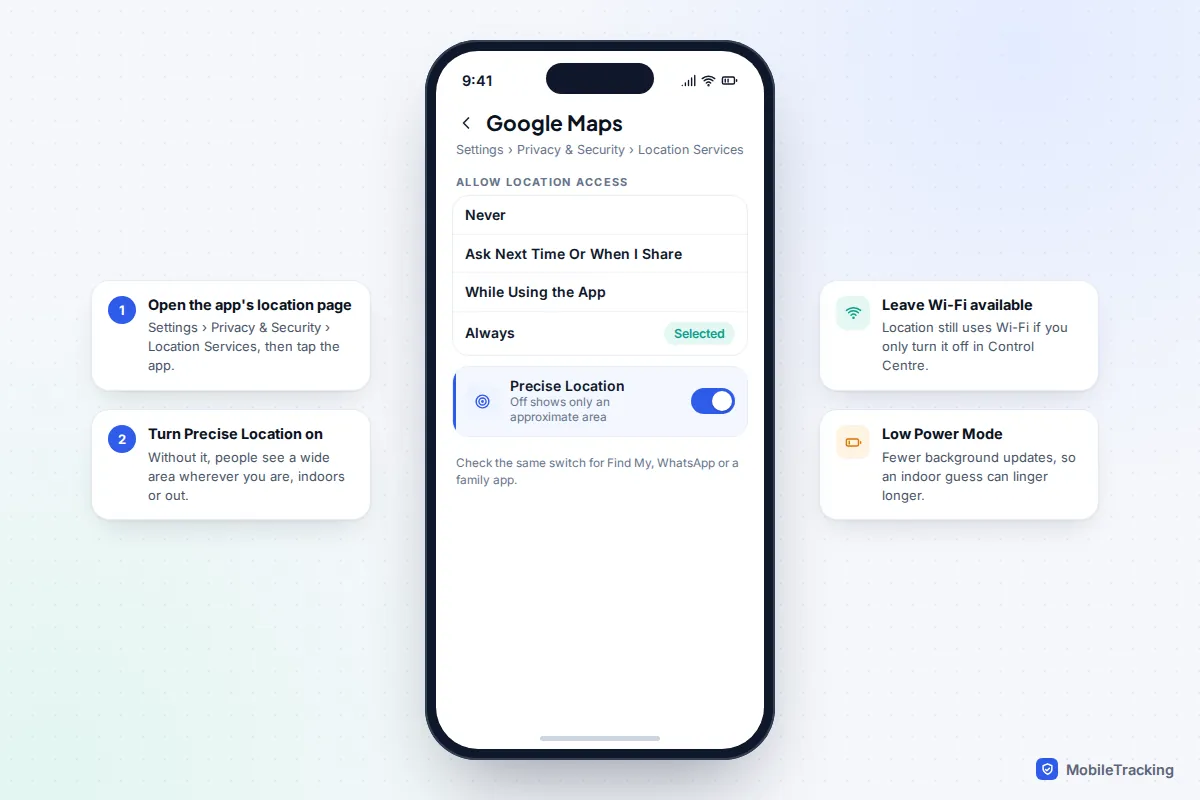
Both iPhone and Android let you give an app only an approximate location. On Android, Google’s developer documentation says an approximate estimate is accurate to within about 3 square kilometres, compared with usually about 50 metres for a precise one. On iPhone, turning Precise Location off for Find My or another sharing app means people see a general area rather than a point. If someone’s location is always a large circle, indoors or out, this is the first thing to check.
Wi-Fi and scanning switched off
Because Wi-Fi does most of the work indoors, turning it off fully makes indoor locations noticeably worse. On iPhone, tapping Wi-Fi in Control Centre only disconnects from networks; Apple’s support page confirms Location Services can still use Wi-Fi in that state. Switching it off in Settings removes it completely. On Android, the safety net is Wi-Fi scanning, which lets the phone use nearby networks for location even when Wi-Fi itself is off.
Battery saving and stale readings
Low Power Mode on iPhone and Battery Saver on Android cut background activity, so the phone reports its position less often. Indoors that matters twice over: the phone may be holding on to a rough Wi-Fi fix, and it isn’t refreshing it. A location that says “25 min ago” might be where someone was in the car park, not where they are now. Phones that aren’t moving also update less often by design. If battery is why settings are turned down, our guide to saving battery while sharing location covers the trade-offs.
The wrong device reporting
From iOS 27, Find My can use a paired Apple Watch’s location when the watch and iPhone are apart, and an iPad can be set as someone’s location device. If a location seems to come from the wrong place entirely, rather than just a few doors along, that is a setup problem, and our guide to fixing location sharing that isn’t working walks through it.
Fixes that genuinely help
Make these changes on the phone being located, not the one doing the looking. Together they usually shrink the circle and steady the pin.
On iPhone
- Go to Settings › Wi-Fi and make sure Wi-Fi is on. You don’t need to join a network.
- Go to Settings › Privacy & Security › Location Services, tap the sharing app (Find My, Google Maps, WhatsApp or a family app) and turn on Precise Location. For third-party apps, choose Always so updates continue in the background.
- In the same Location Services screen, tap System Services and check Compass Calibration and Networking & Wireless are on. Privacy guides sometimes suggest turning these off; if accurate sharing matters to you, leave them on.
- Turn off Low Power Mode in Settings › Battery when accurate updates matter, for example on the way home.
On Android
- Go to Settings › Location › Location services › Location Accuracy and turn on Improve Location Accuracy. Google says this lets the phone use GPS, Wi-Fi, mobile networks and sensors, especially indoors. Pixel phones may label it Google Location Accuracy, and on Android 11 and earlier it sits under Location › Advanced.
- In Location services, turn on Wi-Fi scanning and Bluetooth scanning.
- Open Settings › Apps, choose the sharing app, then Permissions › Location. Select Allow all the time and turn on Use precise location.
- If the direction beam in Google Maps is wide or pointing the wrong way, calibrate the compass by moving the phone in a figure of 8, or tap the blue dot and choose Calibrate. This fixes direction rather than position, but stops the beam swinging about.
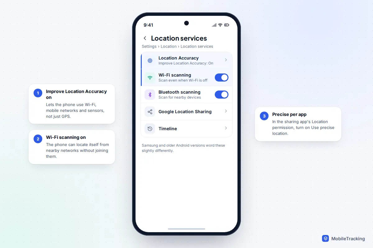
Google’s own page on Android location settings lists these paths for older versions too. Beyond settings, the simplest fix is physical: a minute by a window or just outside the door usually gives the phone a fresh GPS fix, and opening the sharing app prompts an immediate update.
Troubleshooting by symptom
Match what you see to the likely cause before changing anything. Most indoor “errors” are the phone reporting honestly that it doesn’t know exactly where it is.
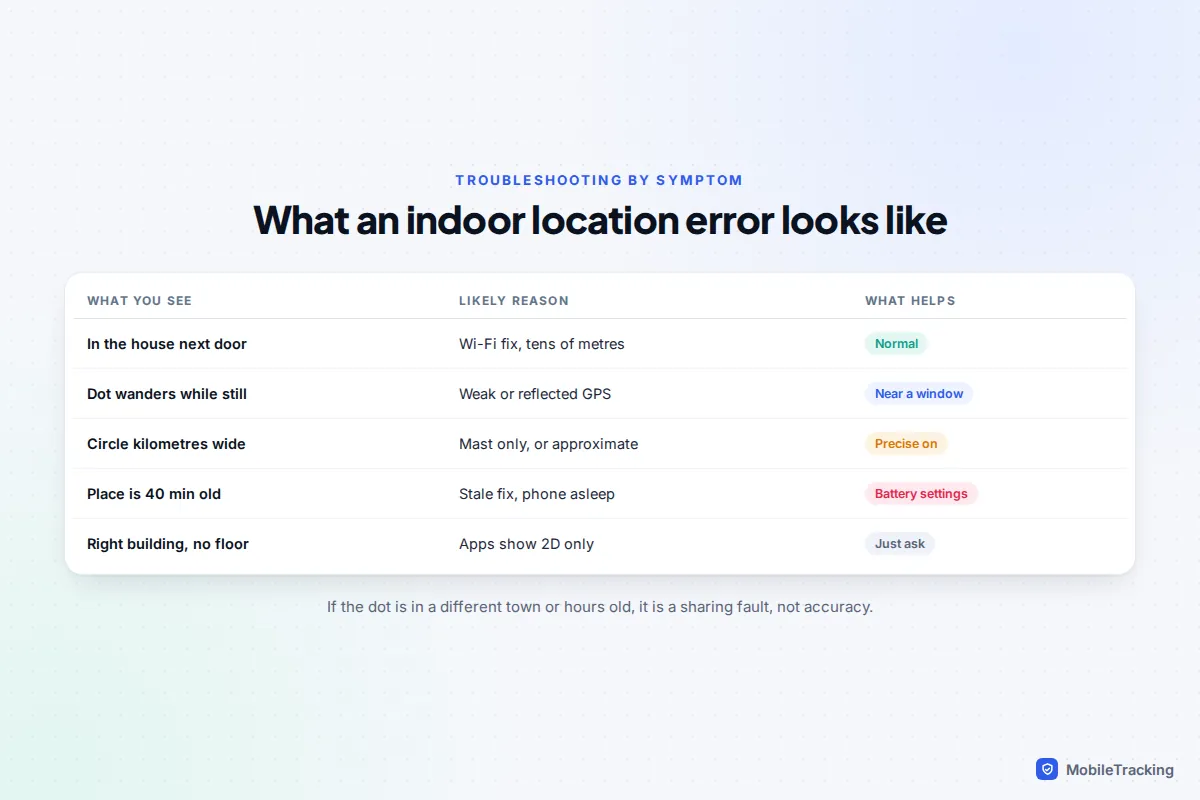
One symptom deserves a note of its own: an “arrived” alert that fires late, or not at all, even though the person is inside. The phone’s indoor fix simply hasn’t landed inside the boundary yet. Draw places generously, covering the whole site plus a margin, rather than a tight ring around the front door; our guide to setting up geofence alerts explains how to size them.
What family apps can and can’t do
Every location app, from Find My and Google Maps to dedicated family locators, asks the same operating system for a position. None has a secret source that works better indoors. An app only controls how often it asks, how it displays the answer and how honest it is about the uncertainty.
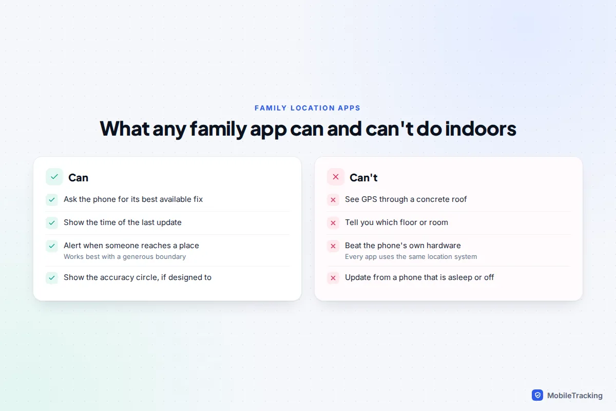
A short scenario shows how this plays out. At 4 pm Priya checks her son Sam’s location and sees his dot two doors down from his friend’s house, where he said he’d be. The circle covers most of the street and the update is two minutes old. That is a Wi-Fi fix in a row of terraced houses, and the right answer is “he’s at his friend’s”. Twenty minutes later the dot is on the high street with a tiny circle: he has walked out to the shop, and the GPS fix is now sharp.
Realistic expectations help: outdoors, a few metres; indoors in a town, the right building or the one next to it; in the countryside or underground, sometimes only the right area. Used openly, with teenagers especially, sharing is a rough guide, not proof of exactly where someone is standing. If a location looks odd, ask before assuming. A child wrongly accused because of a Wi-Fi fix learns that the map is trusted more than they are. For a deeper look at how much you can rely on each method, see how accurate phone location tracking is.
Frequently asked questions
Why does my location show me in my neighbour’s house?
Indoors your phone is probably using Wi-Fi positioning, which is usually accurate to tens of metres rather than a few. In terraced houses or flats that is enough to land the pin a door or two away. Stepping outside or near a window usually corrects it within a minute.
Do I need to be connected to Wi-Fi for better accuracy?
No. The phone only needs Wi-Fi switched on (or Wi-Fi scanning on Android) so it can see the networks around it. Mobile data is enough for the lookup, so joining a network isn’t required.
Can location sharing show which floor someone is on?
Not in Find My, Google Maps or typical family apps. Phones have barometers that can estimate height, and emergency call systems in some countries use that, but everyday sharing apps show a flat map. The best you’ll get is the right building.
Does turning on the accuracy settings drain the battery?
Precise location and Wi-Fi scanning don’t make apps update more often, so they aren’t the main battery cost. What drains power is apps refreshing location constantly in the background. If battery is tight, keep precise location and scanning on and accept less frequent updates.
This guide is general information, not legal or financial advice. Read our editorial policy.